The Charles Anderson Bridge has been closed to all vehicular traffic until repairs can be made.
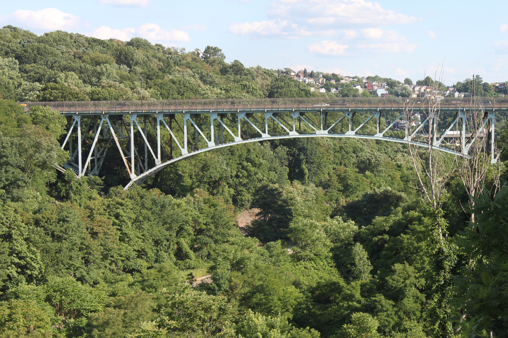
The City of Pittsburgh, in cooperation with the Federal Highway Administration (FHWA) and Pennsylvania Department of Transportation (PennDOT), is advancing the Swinburne Bridge replacement project.
The bridge functions as a critical link between Four Mile Run, South Oakland, Greenfield, Hazelwood, and downtown. It weaves beneath the I-376 Frazier St Viaduct and over CSX/Allegheny Valley railroad, Saline St, serving as a gateway to Four Mile Run.
The current Swinburne bridge, built in 1915, consists of six deck- and thru-girder spans on steel bent towers. While novel for its day, it lacks modern principles of bridge design which provide increased redundancy and decreases future maintenance needs.
The June 16 public meeting has been rescheduled for July 14 at 6:30 PM. At this time, the design team is ready to share preliminary details with the community about the proposed bridge and the construction process.
To allow for improved response time and attendance at the first public meeting, the Zoom meeting previously scheduled for June 16 at 6:30 PM was postponed.
Preliminary engineering is currently underway on the design of a complete reconstruction of the bridge. Preliminary engineering focuses on mapping out and defining the scope of the project as well as the early design of how to take the project from A-to-Z. The design team has been focusing on how to minimize impacts to those who rely on crossing the bridge daily or live and work in the vicinity, as well as how to improve usability for future generations of Pittsburghers.
Move PGH is a pilot program of the Department of Mobility and Infrastructure (DOMI), created to provide Pittsburghers with more affordable, easy to use, and convenient ways of getting around. They are rolling out the installation of mobility hubs throughout city neighborhoods, including two in Oakland in spring 2021.
Visit move-pgh.com for more details. Share your feedback for a location of a mobility hub in Central or South Oakland with DOMI by February 28, 2021.
Mobility hubs are now located in Oakland in two locations - Bouquet Street at 5th Avenue and Schenley Plaza. Move PGH added e-scooters to transportation options in early July 2021.
Project resources:
Move PGH Oakland page (Includes a presentation on potential mobility hub locations in Oakland.)
Project summary: Boundary Street between Joncaire and Neville is a vital connector between North and Central Oakland, and between Oakland and the Eliza Furnace Trail. It's heavily used by cars, bicycles, and pedestrians -- but it's an unsafe passage for all of them, with no sidewalk, no trail, no shoulder, and poor visibility. The Oakland Bike/Ped Committee studied this corridor in 2016, and made recommendations about possible safety improvements that are outlined in detail in this report (below). In 2018 the city allocated $50,000 in its capital budget to establish a bike lane on Neville between Boundary and Fifth Avenue, and OPDC is working with planners in the Department of Mobility and Infrastructure to follow through on this plan and to encourage the city to build a dedicated and protected connection for bicyclists and pedestrians through the entirety of the corridor.
DOMI installed speed humps fall 2019, which has reduced through-speed, and has improved pedestrian safety somewhat. Plans for dedicated at-grade segregated bicycle and pedestrian trail between Joncaire and Neville are currently being developed by DOMI as part of the Mon-Oakland Mobility Project; we're currently waiting for their preliminary plan drawings to be made public so we can share them.
Project resources:
Developer: Department of Mobility and Infrastructure
Project summary: Due to slope instability issues, DOMI closed Swinburne Street between Greenfield Ave and Edgehill St/Childs St on the Greenfield/South Oakland border as of October 21, 2019 to complete improvements. This $710,000 project includes construction of a wall and soil stabilization.
During construction, Swinburne St will be closed to traffic in both directions for approximately five months. Detour routes are posted. Access to the Sestili Nursery will still be maintained.
As of March 9, 2020, Swinburne St has been reopened to traffic. The road will remain open until final paving is done in the spring. Upon completion of paving, Swinburne will then be fully reopened with unrestricted two way traffic.
Swinburne Street has now completely reopened on May 20, 2020. Following seven months of construction, both lanes are now open to traffic.
Developer: City of Pittsburgh
Project summary: PWSA’s 4 Mile Run Watershed Restoration project will daylight Four Mile Run and alter the grading in Junction Hollow, necessitating the reconstruction of trails that currently traverse Junction Hollow. The city’s Department of Mobility and Infrastructure is currently investigating options for supporting mobility through this area, including a pedestrian and bicycle path and the possibility of a trail that could carry light transit between Fifth Avenue and Hazelwood.
At a public meeting on June 20, 2019, DOMI and PWSA presented preliminary ideas for two distinct trails: 1) a mobility corridor that is publicly controlled and accessible to cyclists, small electric shuttles, and users of devises like e-scooters/e-bikes and 2) a trail to support non-motorized transportation for pedestrian and casual cyclists use. No specific design details are currently available for review.
Updates were shared at another meeting on November 21, 2019. Currently, construction is planned to begin in the fall of 2020. The Mon-Oakland Mobility Project website has been updated with current information, as well as links to past meeting notes.
Project resources: